Feeds:
Posts
Comments

Posts Tagged ‘Bike Lanes’

Today marks a very exciting step forward in our continuing effort to implement more cycletracks in Los Angeles. From 12-2pm this afternoon, we tested various cycletrack physical barrier options including armadillos and K71 bollards.  As a refresher, cycletracks, also known as protected bicycle lanes, are on street lanes that separate people on bicycles from motorized traffic by physical barriers such as curbs, planters, parked cars, and posts. They are a relatively new infrastructure that has become more and more popular around the nation.

K71 bollards and armadillos in the buffer zone await bicycles, a sedan, a truck, and the ultimate test: the LAFD fire truck!

Starting at 9 am, LADOT crews began installation of the cycletrack test materials. The installation served as a test for all road users, seeking to understand the various interactions the different types of barriers will face in their everyday contexts.

LADOT crews install an armadillo

Around noon, City employees, Mayor’s Office staff, folks from LACBC and the City of LA Bicycle Advisory Committee helped test the barriers with their bicycles, observing their perception of separation as well as the mountability of the materials.

Testing ridability over the armadillos

(more…)

Read Full Post »

Bicycle tourism has been well observed and practiced as a recreational activity across the United States, but often we fail to remember the multitude of sightseeing opportunities right here within our city’s diverse neighborhoods.  As Los Angeles’ bicycle network and multi-modal connectivity expands, we have more and more opportunities get out of our cars and explore new areas by bicycle. There’s no better way to spend a sunny Sunday than exploring Los Angeles’ hidden gems. We thought we would share our favorite bicycle routes and points of interest in and around San Pedro, one of L.A.’s most scenic and bikeable neighborhoods.

Cruising the Waterfront 1

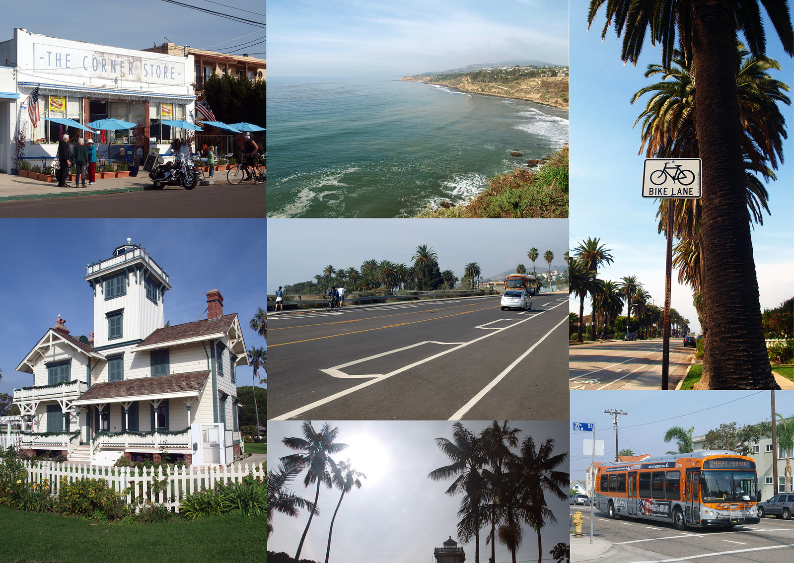
Clockwise from top left: The Corner Store, view from Paseo Del Mar looking north; bike lane signage; Metro Bus 246; palms at Point Fermin Park; Point Fermin Lighthouse; and buffered bike lanes on Paseo Del Mar.

Located 25 miles south of Downtown L.A., San Pedro is home to some of the city’s most breathtaking vistas and historical sights, not to mention bike lanes and paths that even novice riders will enjoy. Our journey begins on San Pedro’s Paseo Del Mar, accessible via the terminus of Metro Bus 246 at Paseo and Parker St. Cruise Paseo’s bike lanes and check out the breathtaking cliff-side views of the Pacific and Catalina Island. Stop by local haunt, the Corner Store to refuel with coffee and snacks before making your way east to Point Fermin Park, home of legendary Walker’s Café and the Point Fermin Lighthouse, built in 1874.

Cruising the Waterfront 2

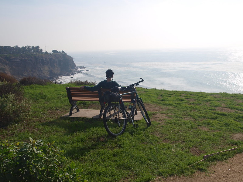
Taking in the view on Paseo Del Mar.

From Point Fermin, it is a quick 5 minute ride down Shepherd and Pacific Avenues to Cabrillo Beach, where you can check out the Cabrillo Marine Aquarium and the nearby tide pools. If squids and urchins aren’t your thing, enjoy the views along the beachfront bike path and fishing pier. Head north on sharrowed Shoshean Road toward 22nd Street where twenty-second Street Park’s scenic bike path will lead you straight to Crafted at the Port of Los Angeles, San Pedro’s new artisan marketplace located in a beautifully restored warehouse.

After picking up some homemade marmalade, head up the hill to Beacon St. to check out the Muller House Museum (open Sundays only), a cherished jewel of San Pedro’s past. Other great sights in the vicinity include: the WPA murals in the San Pedro Post Office on Beacon St,  recently constructed Cabrillo Way Marina and Warehouse No. 1 at the south end of Signal St, which is listed on the National Register of Historic Places.

Cruising the Waterfront 3

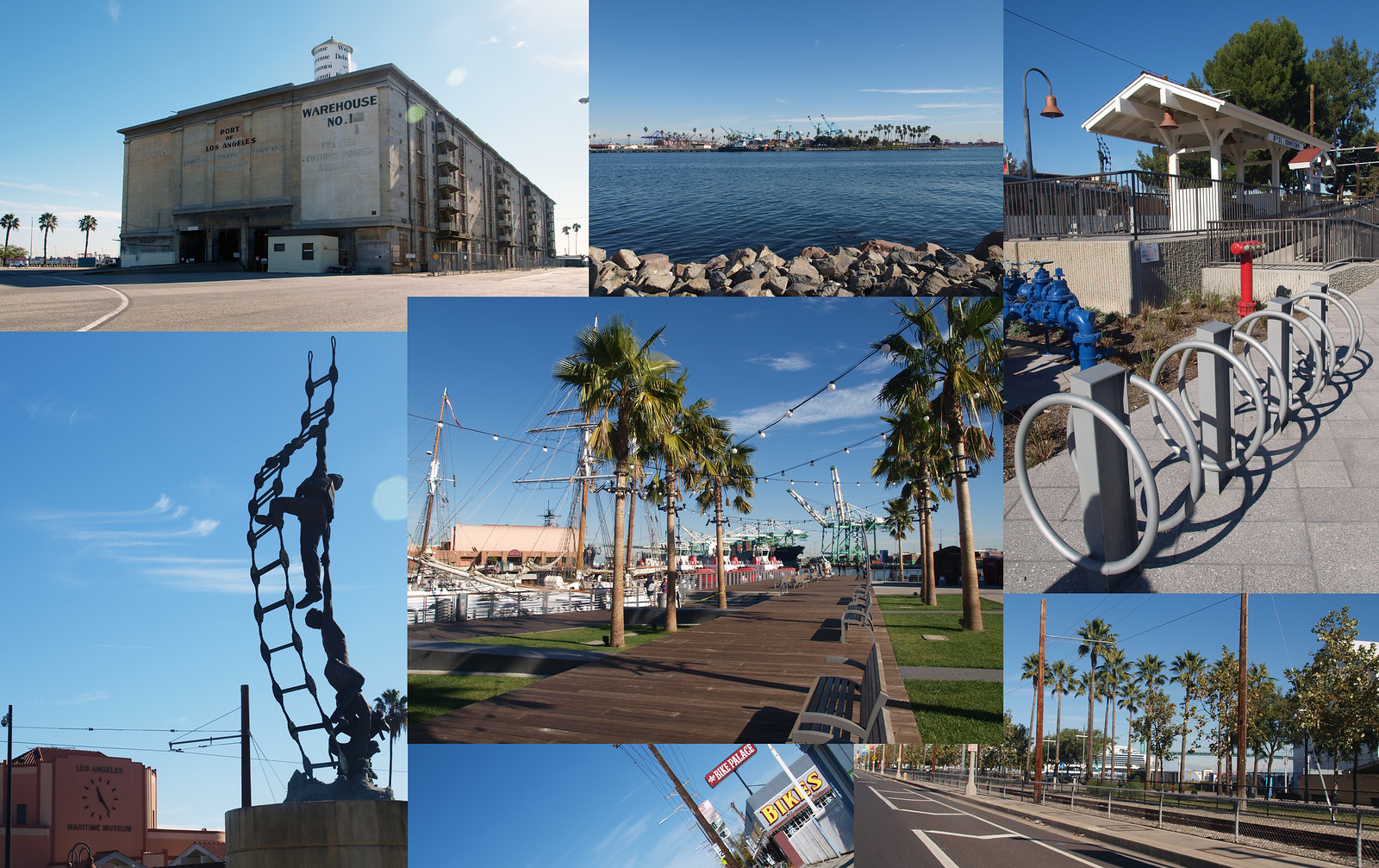
Clockwise from top left: Warehouse No. 1; view from Signal St., bike parking at the Red Car Downtown Station, bike lane on Harbor Blvd., a glimpse of the Bike Palace on Pacific Ave., the Merchant Marine Memorial and Maritime Museum off Harbor Blvd. Center: A brand new boardwalk just north of the Maritime Museum.

Take a well-deserved break at Utro’s Cafe right off of Sampson Way, home to arguably the best burger in town. Peruse Utro’s extensive collection of memorabilia to learn a bit about the history of longshore workers in San Pedro. If you’re still up for more San Pedro sights after lunch, take a stroll around the quaint shops at Ports O’Call. From here you can also take the short trip north to the fantastic Battleship USS Iowa and Los Angeles Maritime Museum both accessible via the bike lanes on Harbor Blvd.

If you want to give your legs a rest, hop on the Historic Waterfront Red Car Line, one of the last remaining vestiges of Los Angeles’ railcar past or enjoy the water show at Gateway Plaza, featuring two Fanfare fountains by WET Design. When you’re ready to catch the 246 back north, take bike-friendly 9th, 13th, or 14th Streets 4 blocks west to Pacific Ave.

Since there’s so much more to see in San Pedro – like the Warner Grand Theater and Korean Bell, just to name a few- feel free to leave us your suggestions for other great bike-friendly sights in town! Also, let us know if you have any suggestions for other bikeable L.A. neighborhoods you would like to see us explore on the blog.

More great resources for your trip: Bike Palace (located on Pacific Ave. and 16th St.); bicyclela.org (for bike maps and parking info)

Read Full Post »

In November 2014, the FHWA published the Road Diet Informational Guide to help communities understand roads diets and their numerous benefits to all roadway users. This past month, LADOT was able to participate in a webinar hosted by the FHWA, which acquainted participants with the new guide. The lessons learned can help inform policies and influence design to create safer streets in our neighborhoods.

As a refresher, road diets (also known as roadway reconfigurations, road buffets, road redesigns, etc.)  are a traffic calming measure that reconfigures roadway space to enhance safety and efficiency for all road users. Road diets can calm and reduce traffic speeds on wide arterials and are an effective safety solution to high traffic speeds, which have caused innumerable traffic fatalities nationwide and in Los Angeles. The most popular design, the standard 4 to 3 configuration, often replaces one auto travel lane with two bicycle lanes, one in each direction, and includes a center turn lane for left turns and emergency vehicles.

Diagram depicts how a road diet is configured when converting from a four-lane roadway to a three-lane roadway.

An example of a typical 4:3 road diet design: FHWA Road Diet Informational Guide

Many of Los Angeles’ arterials were designed during the post-highway planning era. These arterials were built with very wide lanes and often to accommodate a larger volume of cars. Wide lanes are unsafe by design for many users of the roadway because they produce an environment that facilitates speeding and unsafe behavior. The road diet design narrows the travel lanes and is predicted to reduce vehicular speeds and therefore reduce collisions and injuries. Additional benefits include improvements in mobility, access, and livability. There are many misconceptions associated with road diets, but much of these have been refuted by studies and research. The AARP created a fact sheet on road diets, based on nationwide research, showing that road diets are good for business. According to the AARP, “Road diets increase and enhance business activity by reducing traffic speeds (which helps motorists notice the shops, eateries and businesses they’re driving alongside) and by accommodating pedestrians and bicyclists (who tend to spend more money at local businesses than drivers do).”

As has been demonstrated by the successful road diets along York Boulevard & Colorado Boulevard, road diets provide many stand alone safety benefits for all, while simultaneously enhancing connectivity for bicyclists. After the 1.3 mile road diet on York Boulevard between Eagle Rock Boulevard and Avenue 54 was installed in 2006, a detailed traffic analysis showed a 23% and 27% reduction in collisions and injuries, respectively, per mile per year. Many bicyclists already ride on arterials because they connect neighborhoods. Adding bicycle lanes increases safety and bolsters connectivity, while providing additional buffers for pedestrians and shortening crossing distances. Bicycle lanes also create a safety-in-numbers effect, an added safety feedback. People on bicycles may also ride more predictably if a space is designated, reducing wrong way riding and dangerous weaving between parked cars and auto traffic.

A total of 51.9 miles of road diets have reshaped the landscape of streets in Los Angeles since the City began implementing them in 1999. However, many new road diet projects were implemented after the adoption of the 2010 Bicycle Plan. It is important to note that road diets are not just meant to serve bicyclists. Discussing the safety impacts of road diets clarifies that road diets equalize the playing field and create safer streets for people walking, bicycling, taking transit, and driving.

sa12_013

The FHWA Road Diets Informational Guide is detailed and thorough, but if you don’t have the time to read through all of it, here’s a quick list of the key safety and operational benefits for drivers, bicyclists, and pedestrians found in the guide:

  • Decreased number of vehicle travel lanes pedestrians must cross, therefore reducing the multiple-threat crash (when one vehicle stops for a pedestrian in a travel lane on a multi-lane road, but the motorist in the next lane does not, resulting in a collision) for pedestrians
  • Provide room for a pedestrian crossing island
  • Improved safety for people on bicycles by adding bike lanes (such lanes also create a buffer space between pedestrians and vehicles)
  • Provide the opportunity for on-street parking (also a buffer between pedestrians and vehicles)
  • Reduced rear-end and side-swipe crashes for automobiles
  • Improved speed limit compliance and decreased crash severity when vehicular crashes do occur due at lower speeds

With this new information in hand and the FHWA guide in our back pockets, we look forward to working with more neighborhoods to determine where to implement safer roadway design across the City.

Read Full Post »

IMG_0659

July’s Bike Plan Implementation Team meeting was packed!

At our most recent Bicycle Plan Implementation Team meeting, Bikeways Engineer Tim Fremaux briefly noted that the LADOT implemented a number of road diets in the past fiscal year. Although it was only mentioned in passing, after looking at the exact mileage, it turns out this is actually a big accomplishment. Of the 100 miles of bike lanes installed over the last fiscal year, 20.1 miles came in the form of road diets. This comes as particularly promising news from a traffic safety perspective in light of the great safety improvements recently observed on a section of York Boulevard that received a road diet in 2006. So let’s take a page from the SFMTA, and be proud of our road diets, and see exactly where these road diets are:

(more…)

Read Full Post »

IMG_0460

New bike lanes have been popping up all over the city, including this one on Eagle Rock Blvd. Photo credit: Walk Eagle Rock

Why Data Matters For Bikeway Implementation

Over the past two fiscal years, the LADOT Bicycle Program has installed well over a hundred miles of new bike lanes, filling gaps in the city’s bicycle network and enhancing street conditions to make cycling more safe and pleasant. Alongside this effort, the LADOT will also soon be moving forward with highly anticipated bike projects in the city’s first EIR package, marking a huge step forward in the 2010 Bicycle Plan implementation process.

However, great as these accomplishment are, we don’t fully know the impact of bike lane projects and neighborhood bike networks unless we collect data evaluating the impacts of all this new bike infrastructure. How do new bike lanes and road diets affect the number of people bicycling on a street? Do bike lanes improve overall street safety? These are questions we need to answer. Additionally, we don’t know where bike infrastructure is most needed, and has the most potential if we don’t know the popular cycling corridors in the city. Simply put, data collection is incredibly important for evaluating the effectiveness of existing bikeways, and determining how best to advance new bicycle projects.

Since 2009, the Los Angeles County Bicycle Coalition (LACBC) has coordinated – with the help of volunteers – bicycle and pedestrian counts throughout Los Angeles to help measure changes in the level of cycling. The results of the LACBC’s most recent counts, from 2011, observed a tremendous increase in the amount of cycling compared to 2009, particularly on streets that received bike lanes in the time between the two counts. While studies across the nation have demonstrated that building bicycle infrastructure leads to increases in the level of cycling, the LACBC bike counts attach real numbers to actual streets and bike projects in Los Angeles.

How YOU Can Help Future Bikeway Projects

The LACBC is now in the process of coordinating bike counts for 2013. They are scheduled to take place on the 10th and 14th of September, and the LACBC needs your help to put together the most comprehensive and accurate bike counts yet. Because this year’s bike counts will be conducted shortly after over a hundred of new miles have been implemented and with highly anticipated road diets on the horizon, they are especially crucial from a data collection standpoint. The LACBC’s September bike counts will offer an indication of how effective the past fiscal year’s bike lanes have been while offering important “before” data for future bike lane projects.

Ultimately, by simply continuing to count bicycle and pedestrian traffic, the LACBC will be collecting and compiling data the city unfortunately would not otherwise have, while reminding us not to overlook those walking and bicycling on our public streets. All modes of travel matter and deserve to be counted.

Take Action Now

LACBC Bike Count Flyer

LACBC Flyer Promoting the September 2013 Bike Count. Click image for printable version. Image credit: LACBC

If you can, please consider signing up to volunteer for the LACBC’s bike counts. The simple act of collecting accurate data on bicycle and pedestrian usage on our streets will simultaneously help educate Angelenos on the growing popularity of active transportation, evaluate the effectiveness of existing bikeways, and provide valuable data on streets slated for future bikeways.

For more information on the LACBC’s September 2013 bike counts, click here– and to be directly linked to the LACBC bike count volunteer form, click here. For those on facebook, check out the 2013 Bike Count event page.

After you sign up to volunteer, you MUST choose a volunteer orientation session to attend

Read Full Post »

IMG_0170

Did implementing a road diet on York Boulevard make the street safer? Yes, it did! Photo credit: Walk Eagle Rock

When the LADOT proposes a road diet (also known as a roadway reconfiguration) on a street, it primarily does so with the intent of improving traffic safety. As it happens, road diets are frequently opportunities to specifically enhance conditions for people walking and bicycling – the most vulnerable users of our streets – while improving overall safety for all. After decades of study on the national level, road diets are officially acknowledged by the FHWA as a proven means to improve safety and the logistics of why road diets succeed in doing this  have previously been laid out on this blog. (more…)

Read Full Post »

Rendering of the banner on a Collection Vehicle

We’re back with the Don’t Trash the Bike Lanes campaign!  As you may recall, last year we began to design a campaign in partnership with the Bureau of Sanitation to remind Angelenos to refrain from placing their trash cans in bike lanes (or otherwise obstructing them).  The campaign will focus on training Bureau of Sanitation employees to not place refuse bins in bike lanes after dumping, and will raise public awareness with a banner campaign on Sanitation Vehicles. (more…)

Read Full Post »

Older Posts »